
FAVORITE SAILING DESTINATIONS on the EAST COAST
Sailing
Adventures
|
RECOMMENDED SAILING DESTINATIONS FAVORITE SAILING DESTINATIONS on the EAST COAST |
Bill Biega's Sailing Adventures |
|
There are many great sailing areas along the East Coast of the United States. Two destinations are little known to most sailors, therefore they stand out in my mind:
Cumberland Island and Dry Tortuga. | |
|
Cumberland Island
This is a pristine island, a National Seashore, in southern
Georgia, located between the Intracoastal Waterway and the Atlantic.
|
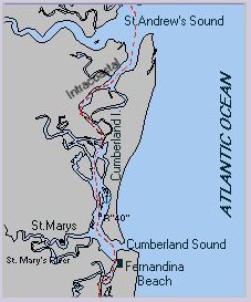
N.O.S. Chart 11489. |
|
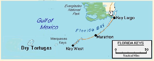
Dry Tortugas
The Dry Tortugas are the only tropical islands within the 48 states. This is a
National Park and a protected area, no commercial fishing is permitted. The only residents are the National Park Service personnel. See a detailed account of a sailing trip to the Dry Tortugas in April 2007. with charts and many photos. In settled weather, visit Loggerhead Key, 3 NM west of the Fort, and its pristine deserted beaches and fantastic snorkeling among coral reefs. The best snorkeling is off the beaches on the west coast, great areas of staghorn coral. Anchor in sand close to the jetty on the east coast, avoiding clumps of coral. Then dinghy ashore and explore. The only people on the island are coastguard personnel at the lighthouse. 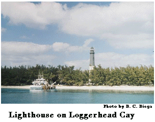
N.O.S. Chart 11438. Start approach to Fort Jefferson anchorage from S. of "Fl.R #2" at 24deg37.5'N 82deg49.8'E., Then 2NM at 298Mag to "Fl.W #3", then 258Mag for 0.78NM to Red Marker #2, then follow the marked channel to the anchorage SE of Fort Jefferson and S of Bush Key, hard sandy bottom, make sure anchor is well dug in. Because of strong tidal currents, a Bahamian moor is recommended. The distance from Key West is 70NM. To reach the anchorage before dark you must leave Key West before sunrise. The only possible anchorage on the way is at Boca Grande, close to the Marquesas Keys, a group of tiny islands about half way. The approach from the west coast of Florida is an overnight voyage. Leave Fort Myers no later than noon. The voyage is straightforward. Make sure you stay to the east of the yellow buoys "L" and "M" at 24deg 42'N 82deg 46'W and 24deg 40'N 82deg 46'W respectively, then proceed to buoy "O" before turning west to R2.
|
|
| Recommended links: St.Marys and Cumberland Island, Dry Tortugas. | |
Return to top of page.
Return to Home page.
Return to Sailing Destinations, List of articles
Copyright © 1998 B. C. Biega. All rights reserved.
Last update: April, 2007
 Anchor in sand opposite
the National Seashore Visitor's Center. Dinghy ashore and walk from the
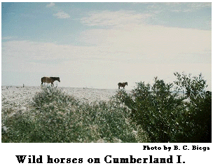
Visitor's Center 1000yds along an easy path through the live oak forest, across the island to the pristine Atlantic beach which stretches 14 miles from Cumberland Sound
almost to St.Andrew Sound. Enjoy the peace of the forest and almost deserted beaches; study the interesting flora and fauna of this sanctuary. If you are fortunate you will see the wild horses that roam the island.
Anchor in sand opposite
the National Seashore Visitor's Center. Dinghy ashore and walk from the
Visitor's Center 1000yds along an easy path through the live oak forest, across the island to the pristine Atlantic beach which stretches 14 miles from Cumberland Sound
almost to St.Andrew Sound. Enjoy the peace of the forest and almost deserted beaches; study the interesting flora and fauna of this sanctuary. If you are fortunate you will see the wild horses that roam the island.
 This is not surprising when you realize that Havana is closer than Miami. Bush Key, which protects the anchorage from the north, is a protected nesting area for terns. They share the islands with hundreds of pelicans and other sea birds. The waters are teeming with fish. If you're lucky you will see tortoises swimming along, quite unconcerned by the anchored boats. No supplies, not even water, are available in the Dry Tortugas. Bring some extra beer. Commercial fishermen, anchored for the night, will often trade a fresh catch of fish, shrimp, and sometimes lobster, for cold beer!